

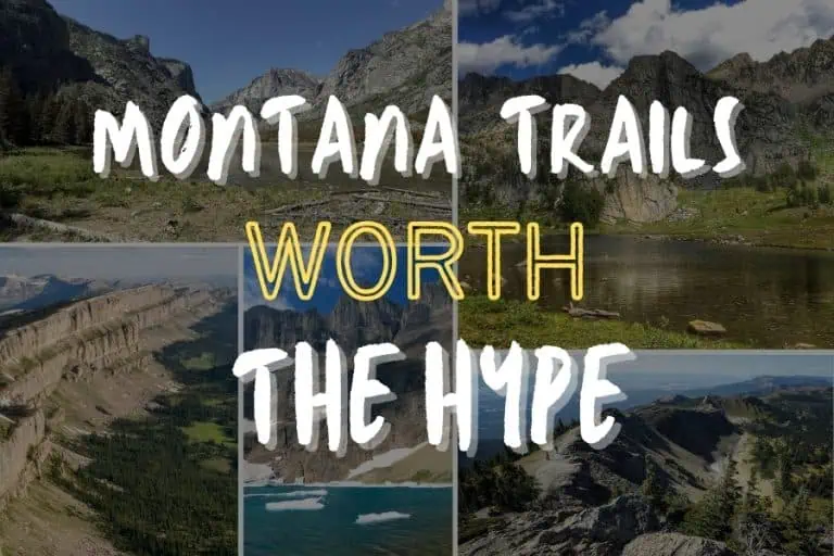
Montana doesn't ease you into its landscapes.
With 25 million acres of public land and more trail miles than most people will cover in a lifetime, the state has a quiet habit of making everywhere else feel slightly ordinary afterward.
The challenge isn't finding somewhere to hike. It's knowing which trails are actually worth the drive.
We asked experienced hikers, trail guides, and outdoor professionals to name the routes that have genuinely stayed with them.
Here's what came back — ten trails spread across the full width of the state, from Glacier National Park's exposed ridgelines to the remote backcountry of the Bob Marshall Wilderness to a Bitterroot canyon most visitors never find:
Glacier's Highline Trail Forced One Hiker to Put Down His Phone for 45 Minutes Straight
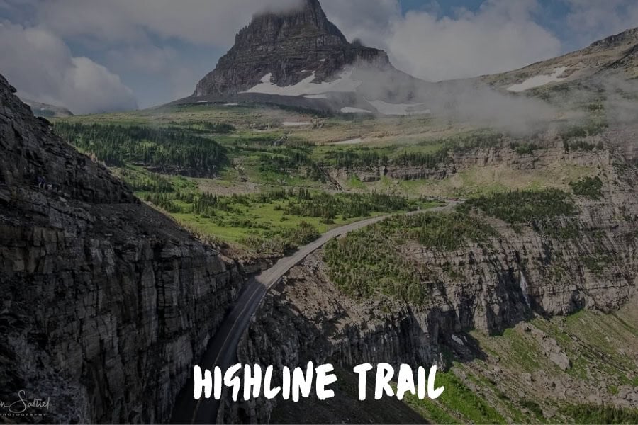
The Highline Trail in Glacier National Park is the one that stays with me and I found it completely by accident on a solo trip I threw together in three days on pure instinct.
A friend texted me "go North" so I rerouted a layover through Kalispell and gave myself 3 days with no agenda and no team around me.
That first ledge at Logan Pass recalibrated something in me because the trail goes about 11.6 miles along the Garden Wall at 6,646 feet with a cable bolted into the rock face and a cliff dropping hundreds of feet to your left.
I have stood in some remarkable places across 4 continents but that ridge is the only place that has ever forced me to be totally present because the mountain just does not give you another option.
By mile four, things got even more spectacular as glaciers, wildflower fields and mountain peaks piled on top of peaks as mountain goats moved across the rock like they had a meeting to get to.
I sat down at a switchback around mile seven and didn't check my phone for 45 minutes, which wasn't the case for so long.
Catch the 6:20 AM shuttle to Logan Pass, slow down and allow yourself the full day.
Steven Bahbah, Managing Director, Service First Plumbing
Grinnell Glacier Trail Takes You to the Edge of a Disappearing World
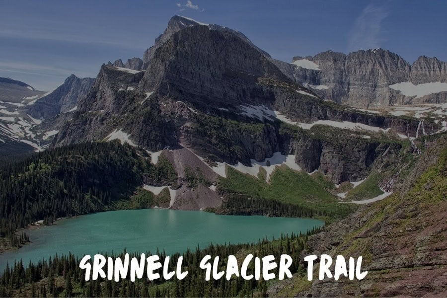
Glacier National Park has no shortage of spectacular day hikes, but the Grinnell Glacier Trail earns its reputation as the park's best by stacking rewards at every mile.
The route runs about 11 miles round trip from the Many Glacier trailhead — or shorter if you take the boat shuttles across Swiftcurrent Lake and Lake Josephine, which is worth doing at least one way.
The trail passes Grinnell Lake, whose turquoise color comes from glacial flour suspended in snowmelt runoff, before climbing to Upper Grinnell Lake at the base of the glacier itself.
The glacier is visibly retreating — park geologists estimate it has lost more than 90 percent of its area since the mid-1800s — and standing at its edge gives the hike a weight that purely scenic routes don't carry. You're looking at something in the process of disappearing.
The Many Glacier area is one of the most wildlife-dense corners of the park. Grizzly bears, bighorn sheep, and mountain goats are regularly spotted on the approach, and the valley itself feels remote in a way that the Going-to-the-Sun Road corridor doesn't quite replicate.
Iceberg Lake in Glacier Holds Floating Ice in August Behind 3,000-Foot Walls
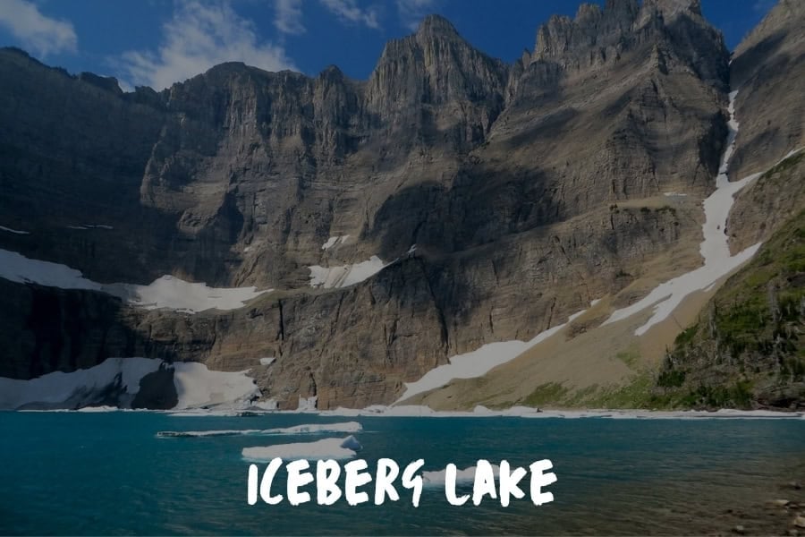
Most Glacier visitors who make it to the Many Glacier area head for Grinnell or the Highline. Iceberg Lake, which sits in a cirque at 6,094 feet surrounded by walls that rise nearly 3,000 feet on three sides, draws a fraction of that traffic — and delivers something genuinely unlike anything else in the park.
The trail runs about 9.7 miles round trip through flower-filled meadows and open terrain before arriving at a lake that holds chunks of floating ice well into August — sometimes into September.
The cirque's geometry keeps the lake in shadow for most of the day, which slows the melt and gives the ice its extended stay. The walls on three sides catch snow year-round, and the scale of the enclosure doesn't fully register in photographs.
The trail is accessible and not especially technical, which makes the payoff feel disproportionate. This is one of the few places in the Lower 48 where you can walk a maintained trail to something that looks genuinely polar.
Jewel Basin Has 35 Alpine Lakes and Almost None of Glacier's Crowds
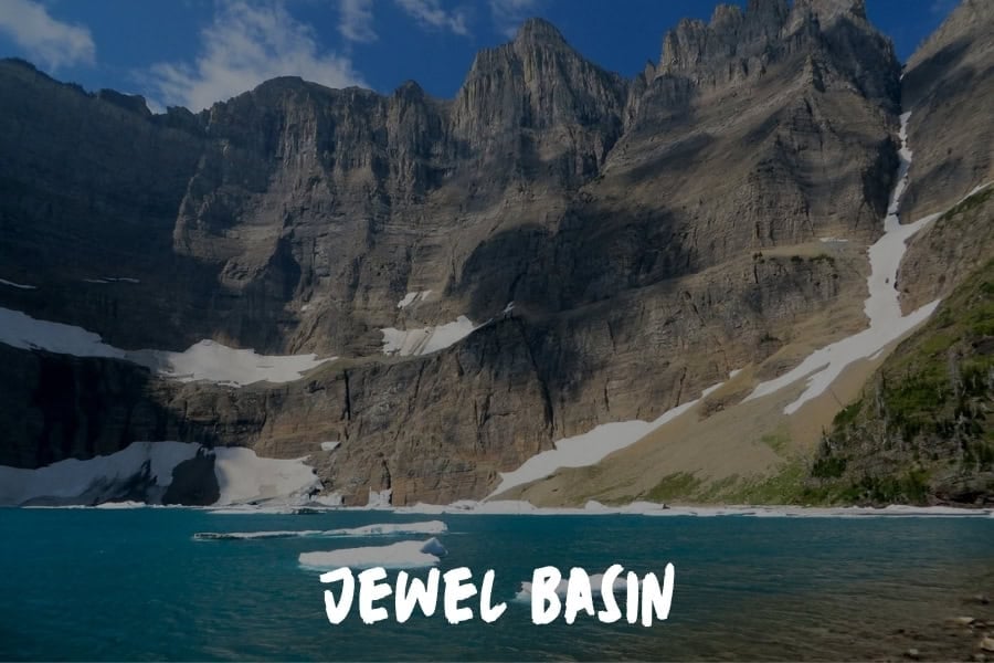
About 40 miles northeast of Kalispell, Jewel Basin Hiking Area sits inside the Flathead National Forest and contains 35 alpine lakes, 35 miles of maintained trail, and a fraction of the visitors that Glacier receives on a typical summer day.
For locals in the Flathead Valley, it's the answer to every question about where to go when Glacier's parking lots fill by 7 AM.
The terrain is compact — the entire area covers about 15,000 acres — which means you can link several lakes in a single day without a massive mileage commitment. Birch Lake and Black Lake are the most visited destinations within the basin, but the network is dense enough that a short detour off the main routes usually delivers solitude.
Jewel Basin doesn't have Glacier's dramatic geological features or its glacier-fed color, but it offers something increasingly rare in popular mountain destinations: the genuine sense that the place isn't being managed around you.
The Chinese Wall in the Bob Marshall Wilderness Takes Days to Reach and Decades to Forget
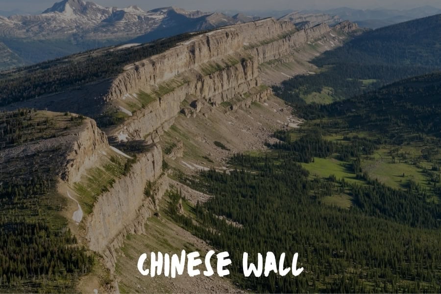
Deep in the Bob Marshall Wilderness, roughly 25 miles from the nearest trailhead regardless of which direction you approach from, the Chinese Wall is a 22-mile limestone escarpment that rises 1,000 feet straight off the Rocky Mountain Front.
It is one of the most dramatic geological features in the American Rockies and one of the least visited — simply because getting there requires committing to multiple days on foot.
Most parties approach via the South Fork of the Sun River or the Spotted Bear River drainage, with the trek to the wall running anywhere from 25 to 40 miles round trip depending on the route.
The Bob Marshall Wilderness covers 1.5 million acres with no roads, no permanent structures, and no cell service — conditions that filter out everyone except the people who came specifically for the silence.
The wall itself runs along the Continental Divide and the views from its base stretch east across open prairie in a contrast that makes no visual sense until you're standing in front of it. This is a trail for people who take remote seriously, and it rewards that seriousness accordingly.
Blodgett Canyon Is the Bitterroot Valley's Best-Kept Hiking Secret
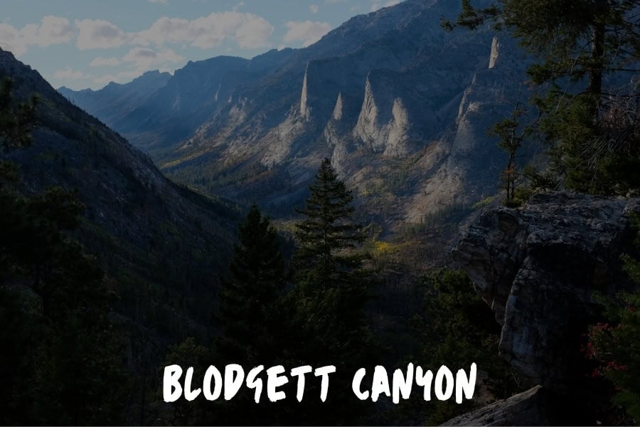
Montana's hiking reputation is built almost entirely on Glacier and the Beartooth country. The Bitterroot Valley, tucked against the Idaho border in the southwestern corner of the state, rarely appears in those conversations — which is exactly why Blodgett Canyon deserves attention.
The canyon trail follows Blodgett Creek into the Bitterroot Mountains, with walls that rise hundreds of feet on both sides as the drainage narrows. The rock is light granite, sharp and clean, and the contrast with the cottonwood and ponderosa at the canyon floor gives the whole place a scale that rewards slow movement.
The trail extends about 9 miles to the upper canyon, passing several pools and small waterfalls fed by snowmelt.
The Bitterroot front is wetter and more vegetated than the east-facing ranges, which means wildflowers through June and July and a creek that runs strong into late summer. For a state where the marquee destinations draw enormous crowds, Blodgett Canyon offers full immersion in Montana's mountain character with almost no competition for space.
Beehive Basin Near Big Sky Gives You Summit Views Without the Suffering
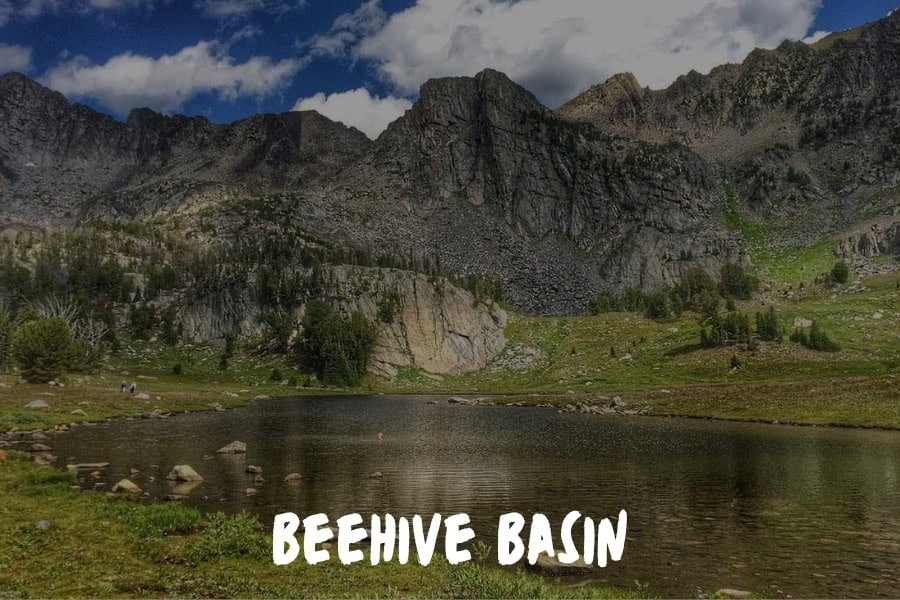
The Beehive Basin Trail is my favorite. It's a gentle climb that doesn't wipe you out, but the views at the top are something else.
I remember walking through those wildflower meadows and feeling like I'd reached a summit without any technical skills.
If you want those big mountain views but don't want a brutal climb, this is your trail. No ropes or ice axes needed. I've seen serious mountaineers and families with small kids up there, and it just works for everyone.
Paul Jameson, Founder & Executive Chairman, Aura Funerals
Lava Lake Is One Hour From Bozeman and Feels Miles From Anywhere
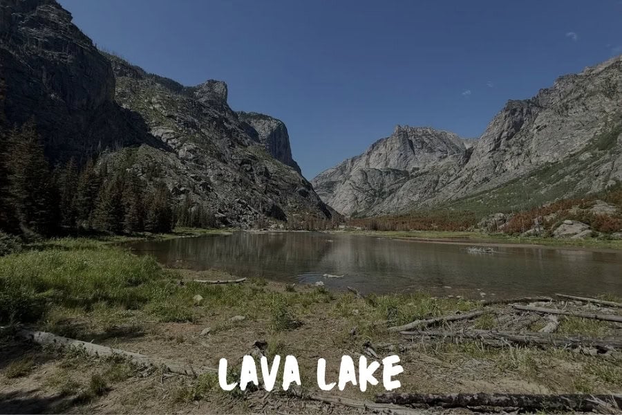
The Gallatin Range near Big Sky gets significant attention for its ski terrain in winter.
In summer, the same mountains offer some of the most accessible high alpine hiking in southern Montana, and Lava Lake sits near the top of that list for the balance it strikes between effort and reward.
The trail runs about 8.5 miles round trip from the Portal Creek trailhead with around 1,600 feet of elevation gain, climbing steadily through lodgepole forest before opening into the upper Gallatin Range above treeline.
The lake itself sits in a cirque below Lone Mountain's southern ridgeline, clear and cold with the kind of stillness that signals genuine elevation.
The trailhead is within an hour of Bozeman, which makes this a realistic half-day option for anyone based in the city or passing through. That proximity hasn't yet translated into crowding — the Gallatin trails remain genuinely quiet compared to the more famous destinations in the region, and Lava Lake captures what makes this range worth seeking out on its own terms.
The Beaten Path Trail in January Will Change the Way You Think About Hiking
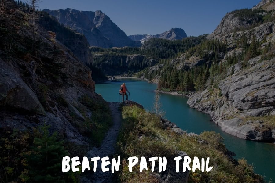
Most people who hike in Montana head directly for Glacier National Park in the summer.
I get it. But I ended up on the Beaten Path Trail in the Absaroka-Beartooth Wilderness this past January and one section of that trail changed the way I think about hiking altogether.
Around mile nine, you come out of the lodgepole pines and the land opens up completely. There are markers of the trail in the summer.
But in January, everything is covered with two to three feet of snow and there is nothing to guide you on the way except for the path you blazed the previous night and a compass in your hand. That one caught me off guard, to be honest. I've been on enough trails where you can turn off your brain and follow the path. That section doesn't have that freedom to do so.
The temperature that morning was around minus eight. No other hikers, no visible markers, just peaks in every direction.
For someone who spends most of his time running a business across two time zones, that sort of demand for focus is difficult to find anywhere else. You're not thinking about email or decisions or what needs to happen next week. You're reading the terrain, you're keeping track of your bearing and you're moving deliberately.
That's what makes the Beaten Path of January my answer every time someone asks about Montana.
John Beaver, Founder, Desky
Final Thoughts: Montana Rewards the Hikers Who Show Up Prepared
These ten trails cover a lot of ground — from a 1.3-mile loop around a volcanic monument to a 40-mile round trip into roadless wilderness. What they share is that none of them are passive experiences. Montana's terrain asks something of you, and what it gives back is proportional to what you bring.
Before you go, check permit requirements for Glacier National Park and the Bob Marshall Wilderness, as both have seasonal restrictions that can affect access. AllTrails is a reliable resource for current conditions and recent trip reports on any of the routes listed here.
Whether you're planning your first Montana trip or filling in gaps in a state you already know well, start with the trail that matches where you are right now — and let the others give you a reason to come back.