

Utah doesn't offer one kind of hiking experience. It offers a dozen, and none of them feel like anything else on earth.
The state stretches from the alpine ridgelines of the Wasatch Front above Salt Lake City to the slot canyons and sandstone arches of the Colorado Plateau, with Zion's red walls, Bryce Canyon's hoodoos, Moab's massive freestanding arches, and the remote canyon country of the Escalante filling everything in between.
Most states have a signature landscape. Utah has five.
We asked experienced hikers, trail guides, and outdoor professionals to share the routes that have stayed with them. Here's what they came back with — nine trails that cover the full width of what Utah can do, from a dog-friendly mountain run above Salt Lake to a multi-day slot canyon loop that serious backcountry hikers plan trips around for years.
Pipeline Trail in Millcreek Canyon Is Utah's Best Dog-Friendly Hike
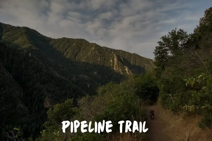
My favorite hiking trail in Utah is the Pipeline Trail in Millcreek Canyon.
What makes it special is that it's one of the most dog-friendly hiking experiences in the state, and the scenery is absolutely stunning without requiring expert-level fitness.
Pipeline Trail runs along the mountainside above Millcreek Canyon with beautiful views of the valley and surrounding peaks.
The trail is relatively moderate, making it accessible for hikers of different skill levels, and on odd-numbered days dogs are allowed off-leash in Millcreek Canyon, which is a huge draw for dog owners who want their pets to experience true mountain freedom.
What makes this trail particularly special is the combination of aspen groves, wildflower meadows in spring and summer, and incredible fall colors. The trail follows an old water pipeline route, so it's consistently graded without steep switchbacks. This makes it perfect for dogs because they can explore without the risk of dangerous drop-offs or terrain that's too technical for their paws.
The community you meet on Pipeline Trail is also what sets it apart. It's filled with fellow dog lovers, and watching dogs splash in the creek at the trailhead before and after hikes has inspired many of the water features we've incorporated at our dog parks.
Utah's commitment to dog-friendly outdoor spaces, including trails like this one, reminds me why connecting dogs with nature is so important for their mental and physical health. Every time I hike Pipeline Trail, I come back with new ideas for making our dog park experience better.
Rina Gutierrez, Part-time Marketing Coordinator, Doggie Park Near Me
Mount Timpanogos Rises Above the Wasatch Front and Asks Everything You Have
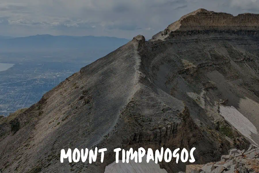
The Wasatch Range runs like a spine along the eastern edge of the Salt Lake Valley, and most people who live in its shadow never make it past the lower trails. Mount Timpanogos, at 11,749 feet, is the peak that changes that calculation.
The most common approach via the Timpooneke trailhead runs about 14 miles round trip with nearly 4,900 feet of elevation gain. The route climbs through aspen groves and open meadows before reaching the Timpanogos Glacier basin, where a small alpine lake sits below the summit headwall. The final push to the summit ridge is steep and exposed, but the views from the top — east across Utah Lake and west toward the Uinta Mountains — justify the effort in full.
Timpanogos is a permit-required hike during peak season, which limits the crowd to something that feels proportionate to the mountain. Go in late July or August when the wildflower display in the lower basin is at full strength, and allow a full day — the mountain rewards people who aren't in a hurry.
Angels Landing in Zion Is the Chain-Gripping Hike That Rewires How You Think About Risk
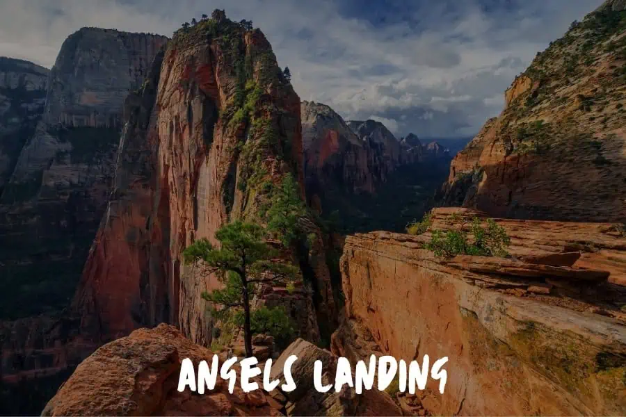
Angels Landing in Zion National Park. No hesitation.
I hiked it a few years back, and it's one of those experiences that rewires how you think about risk and reward. The last half mile is a narrow spine of rock with thousand-foot drops on both sides, and you're pulling yourself up using chains bolted into the sandstone. There's no railing. There's no safety net. You just commit and go.
What makes it special isn't the view at the top, although that view is absurd. It's the mental game on the way up. You watch people freeze at the chain section. Some turn around. And the ones who keep going aren't necessarily the most athletic or the most experienced. They're the ones who decided before they got there that they were going to finish. That's the whole difference.
I think about that trail more than I probably should, because it maps so cleanly onto building a company. There's a point in every hard thing where the path gets narrow, the stakes get real, and most people turn back. The people who make it aren't fearless. They just made the decision earlier than everyone else.
David and I took a trip out to Utah right before we went all-in on our company. We were still at that stage where the idea felt exciting but the leap felt terrifying. Hiking Angels Landing that week wasn't some grand metaphor at the time. It was just a hike. But looking back, the timing was almost too perfect. A few weeks later we committed, applied to YC, and never looked back.
If you haven't done it, go. And when you get to the chains, don't look down. Just grab the next one.
Runbo Li, CEO, Magic Hour AI
The Narrows Puts You Inside the Canyon Instead of Looking Down at It
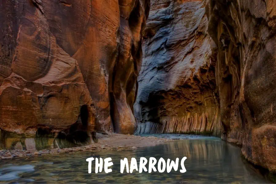
Most of Zion's famous trails sit above the canyon and look down into it. The Narrows inverts that entirely — you're wading up the Virgin River through a slot that narrows to 20 feet wide with walls rising 1,000 feet above your head on both sides.
The bottom-up approach starts at the Temple of Sinawava and follows the Riverside Walk before entering the water. Most day hikers turn around at Wall Street, about 3 miles in, where the canyon tightens to its most dramatic point. The current runs slow in summer but the water stays cold year-round, and proper footwear — canyoneering shoes or neoprene socks with water sandals — makes a significant difference in comfort.
What makes the Narrows unlike any other hike in Utah is that the trail is the river. There's no maintained path, no guardrails — just moving water and ancient sandstone. The canyon changes constantly as the light shifts throughout the day, and the sense of being inside the geology rather than observing it from a safe distance is something no other trail in the state replicates.
Navajo Loop at Bryce Canyon Drops You Into a Hoodoo World Unlike Anything Else
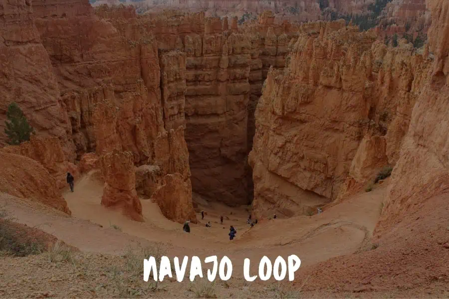
I'm not a hardcore hiker, but the Navajo Loop at Bryce Canyon was incredible.
Dropping down those switchbacks past the hoodoos felt like entering another world. It was tough on the legs but weirdly relaxing for my brain.
I know varied terrain is good for you, but mostly I just liked having a workout that didn't feel like a chore. You should check it out if you want scenery that actually challenges you.
Tobias Burkhardt, CEO, Paretofit
Delicate Arch Earns Its Place on Every Utah License Plate
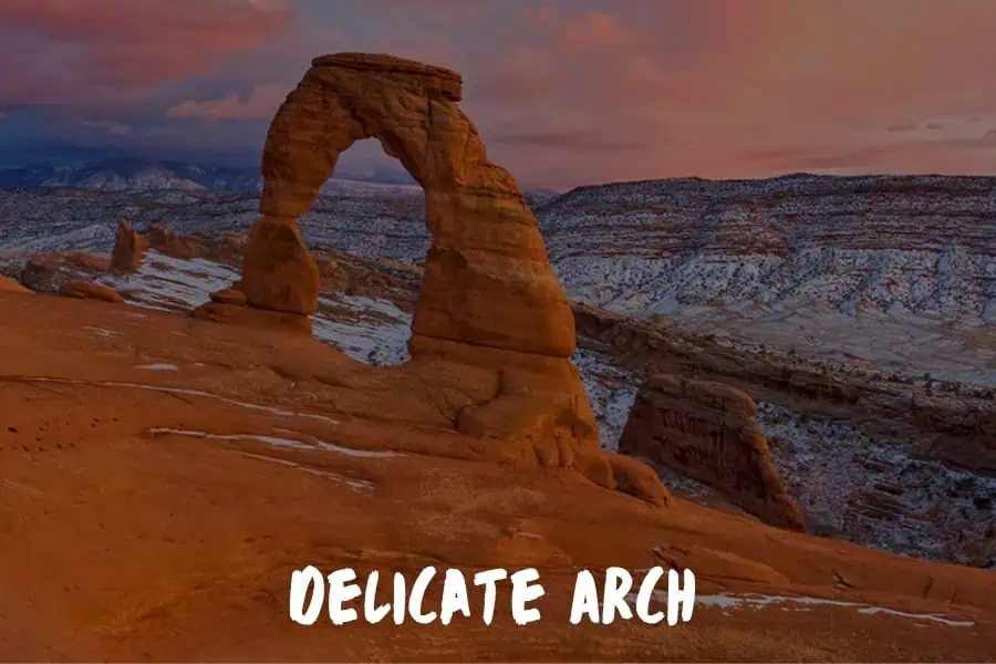
Utah's most reproduced image — a 65-foot sandstone arch framing the La Sal Mountains — doesn't give itself up easily.
The trail to Delicate Arch in Arches National Park is only 3 miles round trip, but the approach is almost entirely exposed slickrock with no shade and no visual hint of what's waiting at the top.
The reveal comes at the crest of a sandstone bowl: you round a narrow ledge, and the arch appears suddenly in full, standing alone at the edge of a natural amphitheater with nothing behind it but open sky and the La Sal Mountains.
The drama of the approach makes the arrival feel like something was arranged on purpose.
Go early morning or late afternoon to avoid the midday heat and the largest crowds.
The light hits the arch differently depending on the time of day — late afternoon turns the sandstone deep orange and makes the La Sal snowcaps glow behind it.
Corona Arch Near Moab Is Bigger Than Delicate Arch and Almost Nobody Knows It
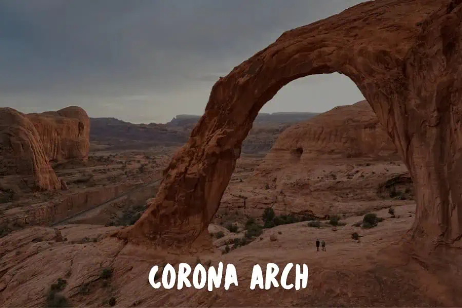
About 10 miles west of Moab on Highway 279, Corona Arch sits outside the boundaries of Arches National Park — which means no entrance fee, no timed entry reservations, and a fraction of the visitors Arches receives on a summer weekend.
The trail runs 3 miles round trip with about 400 feet of gain across open desert and slickrock, passing Bowtie Arch before cresting a ridge and arriving at Corona. At 140 feet wide and 105 feet tall, Corona is larger than Delicate Arch by a significant margin. Two more arches are visible from the same viewpoint.
The Moab area is dense with world-class geology, but Corona Arch consistently delivers one of the best returns on effort in the region. For hikers who want the visual drama of Arches without the permit headaches and parking chaos, this is the answer.
Chesler Park Loop Puts You Inside the Needles and Squeezes You Through the Joint Trail
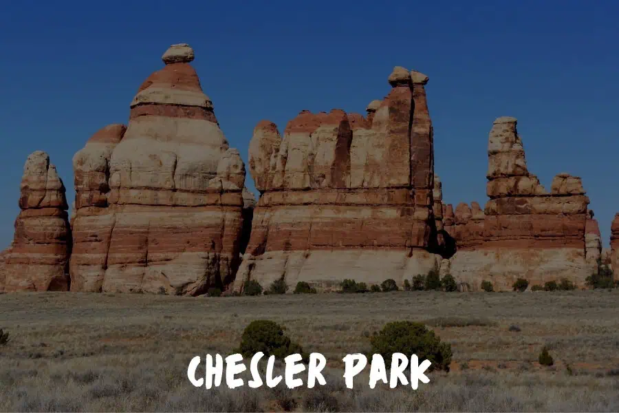
The Needles District of Canyonlands National Park receives a fraction of the attention that the more accessible Island in the Sky district gets, and the Chesler Park Loop is the primary reason that's worth correcting.
The 11-mile loop passes through Chesler Park — a wide open grassland meadow ringed by cedar-red and white-banded sandstone spires that give the Needles district its name — before descending into the Joint Trail, a slot canyon so narrow hikers turn sideways to fit through it.
The contrast between the open meadow and the enclosed slot, separated by only a mile of trail, is one of the more disorienting transitions in Utah hiking.
The Needles requires a high-clearance vehicle to reach the trailhead and tends to filter out casual visitors accordingly.
The loop can be done as a strenuous day hike or an overnight backpacking trip, and the night sky from Chesler Park on a clear night is as good as anything in the Southwest.
Coyote Gulch Is the Multi-Day Slot Canyon Route That Belongs on Every Serious Hiker's List
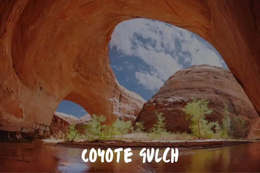
Grand Staircase-Escalante National Monument covers nearly 1.9 million acres of canyon country in southern Utah (more land than some states), and Coyote Gulch is its defining route.
The most complete loop runs 27 to 35 miles, depending on the approach, and typically takes three to four days, threading through a concentration of arches, natural bridges, slot canyons, and hanging gardens that has no equivalent in the Lower 48.
The route passes Jacob Hamblin Arch, Coyote Natural Bridge, and a series of canyon walls streaked with desert varnish and draped in hanging alcove gardens fed by seeps in the sandstone. The Escalante River confluence at the canyon's end adds a sense of arrival that shorter routes can't replicate.
Coyote Gulch requires navigation skills, route-finding experience, and gear appropriate for technical desert terrain. It is not a trail in the maintained sense; it's a canyon you follow. That distinction is exactly what makes it the kind of place backcountry hikers plan trips around for years before they go, and return to for years after.
Final Thoughts: Utah Rewards Every Level of Hiker Who Shows Up Ready
These nine trails span the full range of what Utah offers — a dog-friendly mountain run above Salt Lake City, three perspectives on the same chain-gripped ridgeline in Zion, a river walk through the narrowest canyon in the country, a hoodoo descent at Bryce, iconic arches near Moab, and a multi-day slot canyon trip in the Escalante backcountry.
No other state packs this much variety into one hiking list.
A few practical notes before you go: Angels Landing now requires a permit through the Zion lottery system, and Mount Timpanogos has seasonal permit requirements during peak months, so check the relevant NPS and Forest Service pages before finalizing plans.
For current trail conditions and trip reports on any of these routes, AllTrails is the most reliable real-time resource.
Start with the trail that matches where you are as a hiker right now.
Let the others give you a reason to come back to one of the best hiking states in the country.