

On a clear day, the views reach all the way to Vancouver Island, and the alpine meadows go gold and purple in late July.
You either understand immediately why people come back here, or you don't.
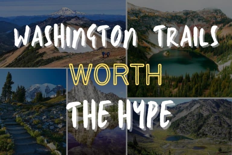
Washington's hiking doesn't run on a single type of terrain.
This guide covers seven trails across the state — from a 0.8-mile rainforest loop accessible to almost anyone, to a 13-mile PCT traverse through open wilderness.
Hurricane Ridge in Olympic National Park Starts at 5,242 Feet — and the Wind Tells You Everything
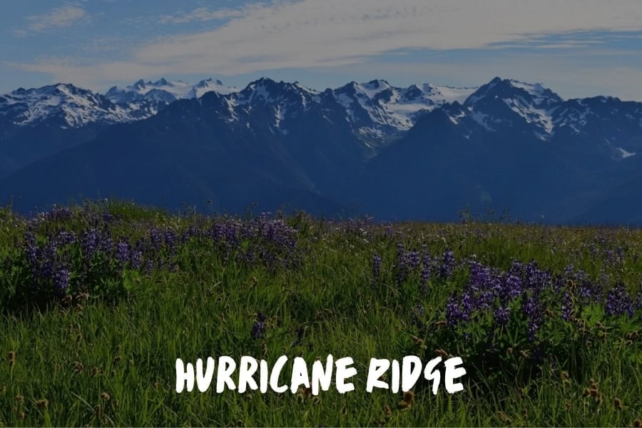
The Hurricane Ridge Trail in Olympic National Park begins at the Hurricane Ridge Visitor Center, already above treeline, with open alpine meadow within the first half mile. No warm-up miles through forest. You're in it immediately.
Hurricane Ridge is my trail and I have gone back more times than I can count since first discovering it on a trip down from Langley.
You step out of the car at 5,242 feet and the wind hits you across the chest, cold and constant off of the Olympic Mountains. Wind does not lie up there. Most people pull their jackets around them tighter and walk faster and I just stand there and read it, the direction, the pressure, the way it rolls over the ridgeline.
On a clear day the views extend all the way to Vancouver Island and the alpine meadow in late July is gold and purple that makes you stop dead in your tracks. Bring a real jacket and go on a weekday when the weather is not lying.
Barbara Robinson, Marketing Manager, Weather Solve
The Hoh Rainforest Gets Up to 170 Inches of Rain a Year — That's Exactly Why You Should Go
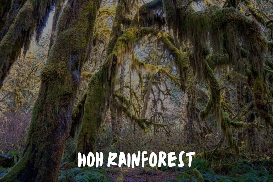
The Hoh Rainforest in Olympic National Park receives between 140 and 170 inches of rain per year. That number explains the big-leaf maples draped in clubmoss along the Hall of Mosses trail — the canopy blocks so much light that even midday feels ambient, and the moss grows thick enough to muffle sound. The loop covers 0.8 miles and takes 20 minutes at a walking pace, or an hour if you stop, which you will.
For hikers who want more, the Hoh River Trail extends 17 miles to Blue Glacier at the base of Mount Olympus.
The first 12 miles follow the river through old-growth Sitka spruce and western red cedar — trees that have been growing since before European contact. The trail gains only 400 feet in those first 9 miles before rising sharply toward the glacier. Day hikers who cover the first four or five miles will see enough old growth to understand what this forest actually is.
Most visitors stop at the Hall of Mosses and leave. The ones who walk even two or three miles up the river trail encounter a version of the Olympic backcountry that doesn't photograph easily. It has to be walked at the right pace, in the right conditions, with no specific destination in mind — the rainforest rewards patience more than any other terrain type on this list.
Chain Lakes Loop Near Mount Baker Circles Three Alpine Lakes With Two Volcanoes on the Horizon
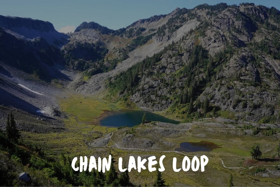
The Chain Lakes Loop trailhead at Artist Point sits at 5,100 feet, so the hike begins above treeline without any climbing to get there. The 6.5-mile circuit passes through three alpine lakes — Mazama, Iceberg, and Hayes — with Mount Baker and Mount Shuksan sharing the horizon for most of the route. At Hayes Lake, near the midpoint, Shuksan's pyramid shape reflects directly in the water on calm mornings.
The Chain Lakes Loop gains roughly 1,700 feet in total, distributed across two short, steep sections rather than a sustained climb. Terrain shifts from lava rock to meadow to snowfield crossings depending on timing — late July through mid-September is the reliable window, after Highway 542 opens to Artist Point and before the road closes for the season. In a heavy snow year, the road can stay closed into early August.
The compressed access window is what keeps this trail proportionate to what it's offering. Hikers who can go on a weekday in mid-August — when the road is open and the September crowds haven't arrived — will find the trail quiet in a way that doesn't match its quality. The views from the ridge section above Iceberg Lake are among the most unobstructed volcano views in the state, and the morning reflections in the lower lakes make the early-start timing worth planning around.
Maple Pass Loop in the North Cascades Has a 10-Day Window in October When the Larches Turn Gold
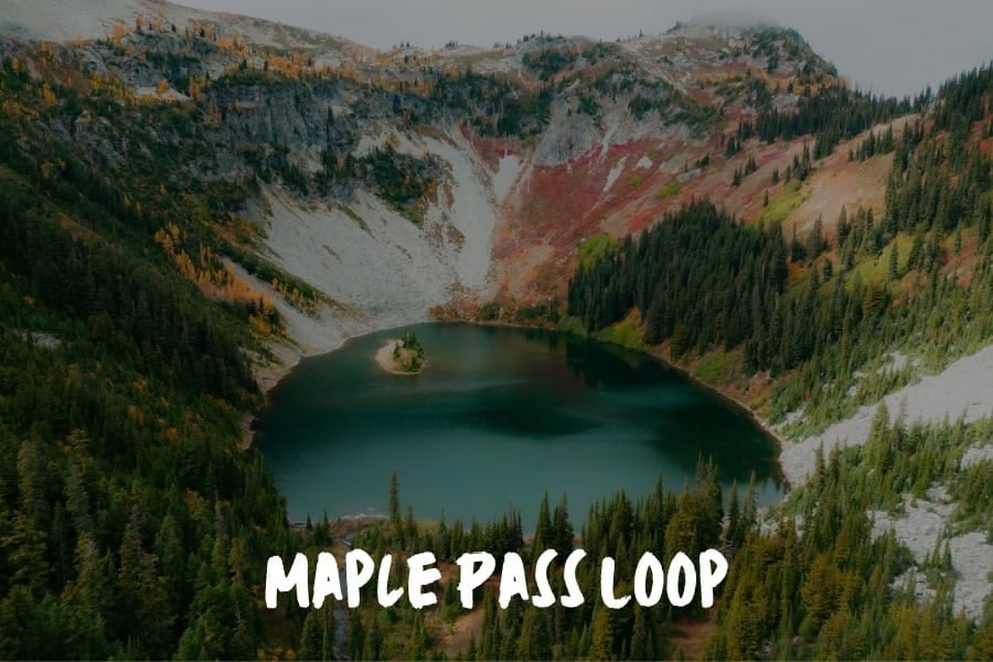
The Maple Pass Loop doesn't save its best view for the summit. At mile 1.5, the trail crests into a direct view of Lake Ann sitting in a granite cirque with Maple Pass rising directly above it. The remaining 5.5 miles are spent circling the rim of that basin, gaining the ridge, and descending back through subalpine fir. The full 7-mile circuit gains 2,000 feet, with the high point at 6,950 feet.
Trailhead access is simple: the Rainy Pass parking area sits directly off Highway 20 in the Okanogan-Wenatchee National Forest. The Maple Pass Loop runs from late July through mid-October, with one important caveat: in late September and early October, the subalpine larches along the upper ridge turn a deep gold that changes the character of the hike entirely. That window is roughly 10 days wide, and the crowds know it.
What distinguishes this loop from other Washington ridge hikes is consistency. There's no single dramatic moment. The quality distributes itself evenly across all 7 miles — lake, cirque, ridge traverse, descent through trees — which makes it one of the few Washington hikes that rewards moving slowly rather than pushing for the top. Hikers who've done Maple Pass once tend to come back during the larch window. Hikers who do it during the larch window tend not to go anywhere else that week.
The Enchantments in Alpine Lakes Wilderness: 75 Overnight Permits Per Day, and Two Hikers Who Got One
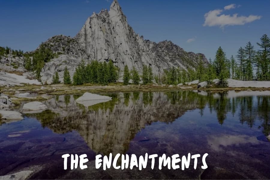
Both entries below cover the same trail — the Enchantments in the Alpine Lakes Wilderness above Leavenworth. The overnight lottery opens each February via Recreation.gov, with 75 permits issued per day. Both hikers arrived separately and came back saying the same thing.
The Enchantments sits at the top of my list, and I don't say that lightly.
I've hiked a good number of Washington's trails over the years, and nothing quite compares to stepping into that high-alpine basin for the first time. The turquoise lakes are stacked against granite peaks. During October, the larches turn gold, and the whole place feels like it exists outside our time.
Getting there isn't easy. The lottery system for overnight permits (only 75 issued daily) keeps the crowds so controlled that you can be alone in the place. I remember thinking the permit process was ridiculous before I got there. After getting there? It made sense. The difficulty of access is exactly what keeps it what it is.
Reilly Renwick, Chief Marketing Officer (Brand, Growth, Demand Gen) | Full-funnel GTM systems | Content, Creative & Performance Lead, State of the Wall
Skyline Trail at Mount Rainier Goes From Wildflower Fields to Glaciers Without Requiring Technical Skill
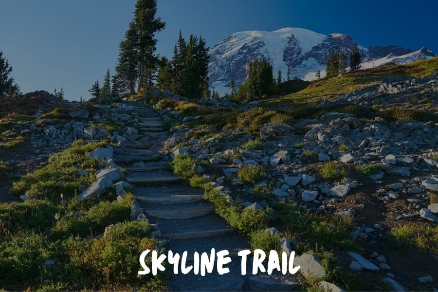
The Skyline Trail Loop at Mount Rainier National Park covers 5.5 miles and roughly 1,400 feet of elevation gain, circling above Paradise through subalpine meadows and along the edge of the Nisqually Glacier.
Skyline Trail. I always make a point to revisit this amazing trail whenever I'm in Washington. What makes it special is how quickly the environment shifts as you climb. You start in subalpine meadows, and within a relatively short distance, you're looking out over glaciers, volcanic rock, and wide, open ridgelines around Mount Rainier.
From a traveler's perspective, it's one of the rare trails that delivers a full-spectrum experience without requiring extreme technical ability. On a clear day, you'll see wildflower fields in the foreground and snow-covered peaks in the distance, which creates a contrast that's hard to find elsewhere. I've also found that hiking it solo feels surprisingly grounding. Even though the trail is popular, it never feels crowded, so you still get moments of quiet.
Before you go, plan to start early because the weather around Rainier can shift quickly, and visibility is everything on this trail. When you catch it at the right time, it's one of those hikes that reminds you why the Pacific Northwest has such a strong reputation for raw, unfiltered landscapes.
Declan Somers, CEO, Mobal Communications
The Knife Edge in Goat Rocks Wilderness Puts Three Volcanoes on the Horizon at 7,600 Feet
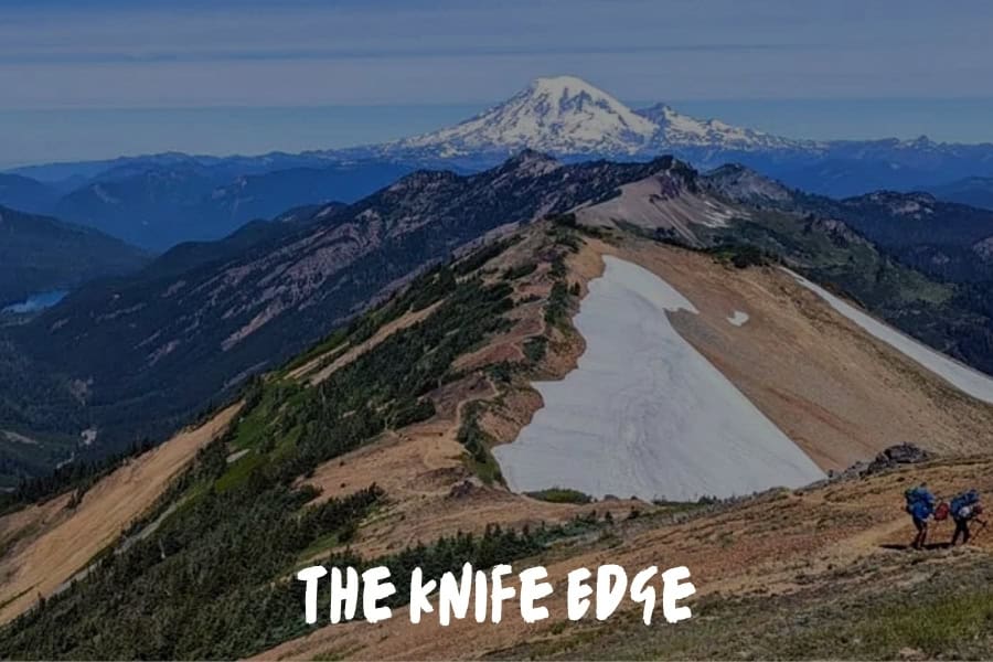
The Knife Edge section of the Pacific Crest Trail through Gifford Pinchot National Forest's Goat Rocks Wilderness sits at roughly 7,600 feet, exposed on both sides of the ridge, with Rainier directly to the north and Adams and Hood behind you to the south. The path is wide enough that it isn't technical, but the exposure requires steady attention — loose rock and afternoon thunderstorms are both real factors from July through September.
The standard approach starts at the Snowgrass Flat trailhead off Forest Road 21, which reaches the PCT in 2.5 miles.
A full day hike covering Snowgrass Flat, the PCT north to the Knife Edge, and back runs about 13 miles with 3,000 feet of gain — long, but manageable with an early start. The overnight option through the wilderness to Packwood Lake is a two-day route that requires a Northwest Forest Pass but no permit lottery — a meaningful difference from the Enchantments.
Goat Rocks draws PCT through-hikers and serious day hikers, both of whom know this as one of the most demanding sections in Washington. Day hikers who plan accordingly find it significantly less crowded than comparable Rainier-area trails, and the three-volcano view from the Knife Edge isn't replicated anywhere else in the south Cascades. The Enchantments may be Washington's most famous permit hike — Goat Rocks is what serious hikers talk about when they're not competing for a lottery slot.
Before You Go: Permits, Conditions, and How to Choose
Permits matter on this list. The Enchantments overnight lottery opens each February. Goat Rocks overnight requires a Northwest Forest Pass but no lottery. Mount Rainier and Olympic both charge an entrance fee; the America the Beautiful pass covers both. The Rainy Pass trailhead for Maple Pass Loop and the Artist Point trailhead for Chain Lakes also require a Northwest Forest Pass for day use.
Conditions shift quickly in Washington, particularly at elevation. So be sure to check current snow levels, blowdown, and trailhead access before driving two hours to a closed road.
The Mount Rainier and Olympic National Park websites update trail status weekly through summer. Highway 20 — which serves the Maple Pass trailhead — closes in November and reopens in spring, with the exact date varying by year.
The range here is deliberate. Hurricane Ridge and the Hall of Mosses are accessible to anyone who can walk a few miles. The Enchantments and Goat Rocks are full-day commitments that require planning.
The three North Cascades trails sit between those extremes — doable for a prepared day hiker, spectacular enough to justify traveling from outside the state. Pick the trail that fits where you are right now. The others are reasons to come back.